
- About the village
- The name
- Maps
- Drainage
- In figures
- Church, Victory Hall etc.
- What people say
- What happens
About the village.
The parish of Hasketon is situated adjacent to the A12 road on the opposite (western) side to the larger market town of Woodbridge. The approximate centre of the village is about a mile further to the west. Other adjacent parishes are Bealings to the south, Grundisburgh and Burgh to the west, and Boulge and Bredfield to the north. It’s a relatively quiet place since it’s not really on the way to anywhere, although the busy B1079 road does cut through the corner of the parish and the even busier A12 runs along its eastern boundary. Structurally Hasketon would be classified as ‘dispersed’ village; that is, it hasn’t really got a centre – originally that is anyway. Developments over the last half century have resulted in a concentration of more modern houses in the areas closer to the church, such as Tymmes Place and Boulge Road. But if you look at an older map you’ll see it is mostly comprised of hamlets based around areas of employment such as local farms, manors and mills. Thus it’s a fairly spacious place.
Farming continues to occupy the majority of land use, which is mostly arable. However, livestock breeding including sheep, horses and cattle do take place, albeit on a somewhat smaller scale. The soil type is mostly heavy clay, though there are some areas of light, sandy soil.
There are a number of businesses in the parish, notably Grange Farm where they have their own farm shop and several associated retail outlets including a cafe, Vehicle Surgeon for all your automotive repairs, and of course the Turks Head Inn.
A number of the smaller roads have recently been designated ‘Quiet Lanes’, although most of the village pretty quiet anyway. Thus it’s a good place to walk/cycle, though do bear in mind that on these narrow country lanes, when things do happen, they can happen very quickly. It’s also a good plan to avoid Manor Road, which is a bit of a rat-run onto the A12, with no speed limit along most of its length.
In common with many rural villages, only a minority of residents are employed in the agricultural sector; the majority travel to work in the surrounding towns, run their own business from home, or are retired.
The name.
Hasketon’s name is generally interpreted as “Haseca’s Homestead”, though unfortunately the identity of Haseca seems to have been lost in the midst of time. In the book, “A Dictionary of Suffolk place-names”, by Keith Briggs, a number of variants of the name through the ages are quoted: Hascetuna, Haschetuna, Hashetuna (1086); Hecetune (c.1100 – c.1207); Asketon (1254); Hasketone (1327); Hectune (c.1333); Hasketon (1336); Haston (1524); and finally Hasketon (1783). He also notes the only other reference to Haseca is in Worcestershire: the placename “heasacan”, which survives as the modern day Axborough. A quick look online suggests the Axborough locals don’t agree, claiming that the Saxon name means hassock grass, but it’s a small place and there don’t seem to be very many of them to argue with anyway.
A particularly important thing about Hasketon, is that it is NOT Hacheston. The fine village of Hacheston is a completely different place about 6 miles away on the road to Framlingham. This has caused lots of confusion over the years, most notably the erroneous claim that in 1640 the so called ‘great champion’, John Bull, was buried in a vault under the church, along with 12 swords and scabbards. The slab with his name on it in the floor of Hacheston church shows where he really is.

Maps.
These days there are a plethora of online mapping resources – these are just a few you might find useful to find your way around:
The embedded maps and satellite pictures here are provided by the American company Mapbox. It’s a very good free online service, allowing you to zoom and pan to provide the map or satellite view you require,
Zoomable village map.
Satellite.
For a little more detail our own Ordinance Survey maps are a little better, though you may need an account to get full access. Here’s a link for an on-line OS map of Hasketon. For historical OS maps the National Library of Scotland is an excellent resource, though the user interface could do with an overhaul.
Suffolk County Council provide down-loadable maps (.pdf format) for all Suffolk parishes from their Definitive Rights of Way site. These are really useful and it’s well worth saving the relevant ones to your phone if you’re out for a walk. The Hasketon map is shown below:
Drainage
Compared to many other Suffolk villages there has been relatively little large scale modern housing development. I suspect this is very much due to the drainage situation – there isn’t any! Almost the entire village has no mains drainage, which means all the houses have to use some form of domestic treatment plant or septic tank. These partially sanitize the effluent, but getting rid of the water can be a problem. The local subsoil is primarily clay, so you either need a large area for land drains or access to a watercourse. Not all the modern houses have this, so there are sometimes… problems! Thus anyone hoping to build a housing estate has this hurdle to overcome, and if you’re planning to buy a house in the village, check the drainage. I mean seriously, CHECK THE DRAINAGE!
In many areas of the village the highways drainage is also very poor. Very few of the gullies remain operational and we’ve been on at Suffolk County Council to sort them out for what seems ages.
Hasketon in figures.
- Population in 2021: 398 (M:187, F:208)
- Area: 6.8 sq km
- Latitude, longitude (Parish church): 52.106454, 1.284345
- What3words key: “mural.bottle.icicles”
- OS Grid reference: TM248506
- Parliamentary constituency: Central Suffolk and North Ipswich.
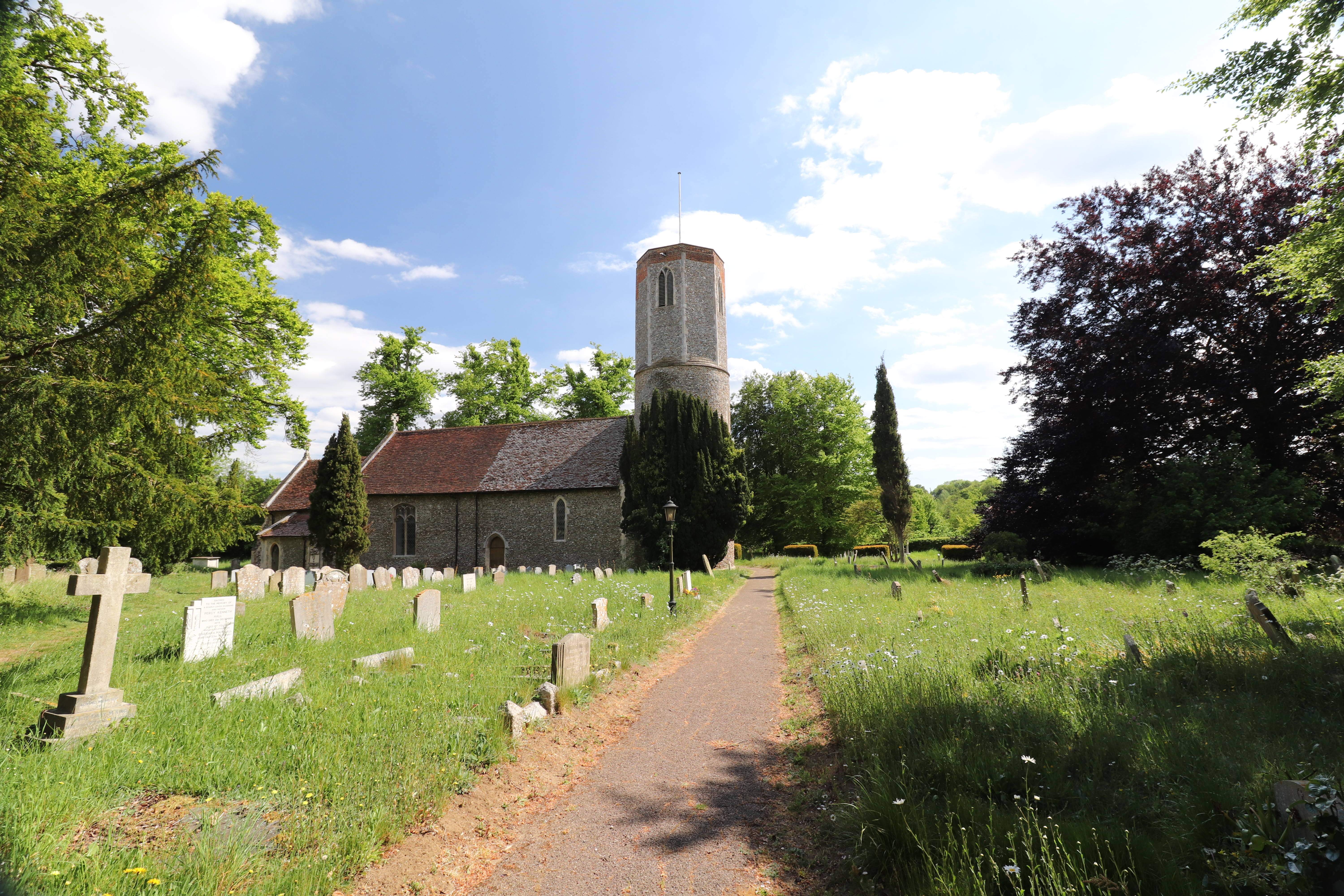
The Church
St Andrew’s Church has it’s origins in the 11th century, and is particularly notable for it’s round tower – in fact it is the tallest round church tower in the country.
Round towers churches are very much an East Anglian thing – nationally there are 186, Norfolk has 124 and Suffolk has 38. Since there is little solid rock available locally, the medieval builders naturally took advantage of what they had lots of – flint. And since round structures are inherently stronger than square ones, that was the way to go with the irregularly shaped flints held together with lime mortar. For more on round tower churches, visit the Round Tower Churches Society website. The society published a very detailed analysis of Hasketon Church in the March 2009 edition of their magazine. Another nearby round tower church can be found in the small village of Ramsholt on the banks of the River Deben estuary.
Of particular interest are two pieces of stone from the 12th century and the 15th century font with Tudor roses. The outside of the church is noted for the round tower dating from Norman times and some early masonry work from the 11th century.
St Andrew’s is open every day and all visitors are very welcome to enjoy the peace for a quiet prayer or join us for our various Sunday services and other events.
The Victory Hall
The main communal facility is ‘The Victory Hall’, situated on the opposite side of the road the Church. It was erected in 1920, having begun its life as a WW1 YMCA hut at the army camp at Rendlesham. Following the armistice in 1918 the camp was closed down and the assets all sold off. More details of this can be found on The Victory Hall page.
The Village Green and playground.
The Village Green is adjacent to the Victory Hall and consists of large grassy area with a range of playground equipment that should cater for most age groups. Nearby is another grass area, slight rougher in nature, which is used as a car park.
The Turks Head
The village pub is called The Turks Head. It is situated in Low Road, about 500 yards from the Church and Victory Hall. It’s a fairly typical country pub serving a variety of beers and food. There is an Official Website, where you can book tables etc, and an unofficial page on this site that covers the history of the Turks Head.
Schools.
The original village school closed some years ago, and is now a private house next to the church. There are 3 primary schools in Woodbridge: Woodbridge Primary School is the ‘official’ catchment school, Kyson Primary School is popular, and the children of the faithful might get a place in St. Mary’s Primary School.
The catchment secondary school is Farlingaye High School, just on the other side of the A12. There is a school bus so the kids don’t have to walk along the pavementless Blacksmiths Road to get there. Its performance as a school has varied over the years, depending on the Head Teacher, but it is generally pretty well regarded.
What people say about Hasketon
Over the years many people have set out to describe the village, with varying degrees of success. For example, White’s Suffolk Directory (1844) says:
HASKETON, a straggling village, 2 miles NW of Woodbridge has in it’s parish 508 souls and about 1600acres of land including Thorpe Hall estate, which forms a separate manor about a mile west of the village….. The Church (St. Andrew) is an ancient fabric with a tower, round at the base and octangular at the top. ‘
Well the figures are interesting of course, but ‘a straggling village’? I’m not sure I like that – it makes the village sound a bit unkempt (OK, some of it is, but that’s not the point). I’ll be charitable and assume Mr. White was writing under time pressure and couldn’t think if a more polite word. The technical term for a village like Hasketon, which is in many ways more like a collection of small hamlets is, ‘non-nucleated’, or ‘dispersed’. Describing the church as ‘an ancient fabric’ is odd too. It makes it sound like a tatty old jumper.
Kelly’s Suffolk directory in 1900 describes the village a little differently:
Hasketon is a village and parish about 3 miles northwest of woodbridge… The church of St. Andrew is a building of rubble in the Early English style… The soil is mixed; subsoil gravel and clay. The chief crops are wheat, barley and turnips. The area is 1680 acres; ratable value £2,689; the population in 1891 was 414…. Parochial school (mixed), built in 1871 and enlarged in 1883 …. average attendance 48. Mrs. Mary Elizabeth Small, mistress.
‘A building of rubble’! Ignorant fool. It’s flint – a fine building material used all over East Anglia. I also note the village has moved a mile further away from Woodbridge since White’s directory was published. He’s right about the gravel and clay though. Just try doing a pecolation test so Binder can design you some drains – the water sits there for ever!
The entry in Wikipedia is somewhat better, but a bit dull:
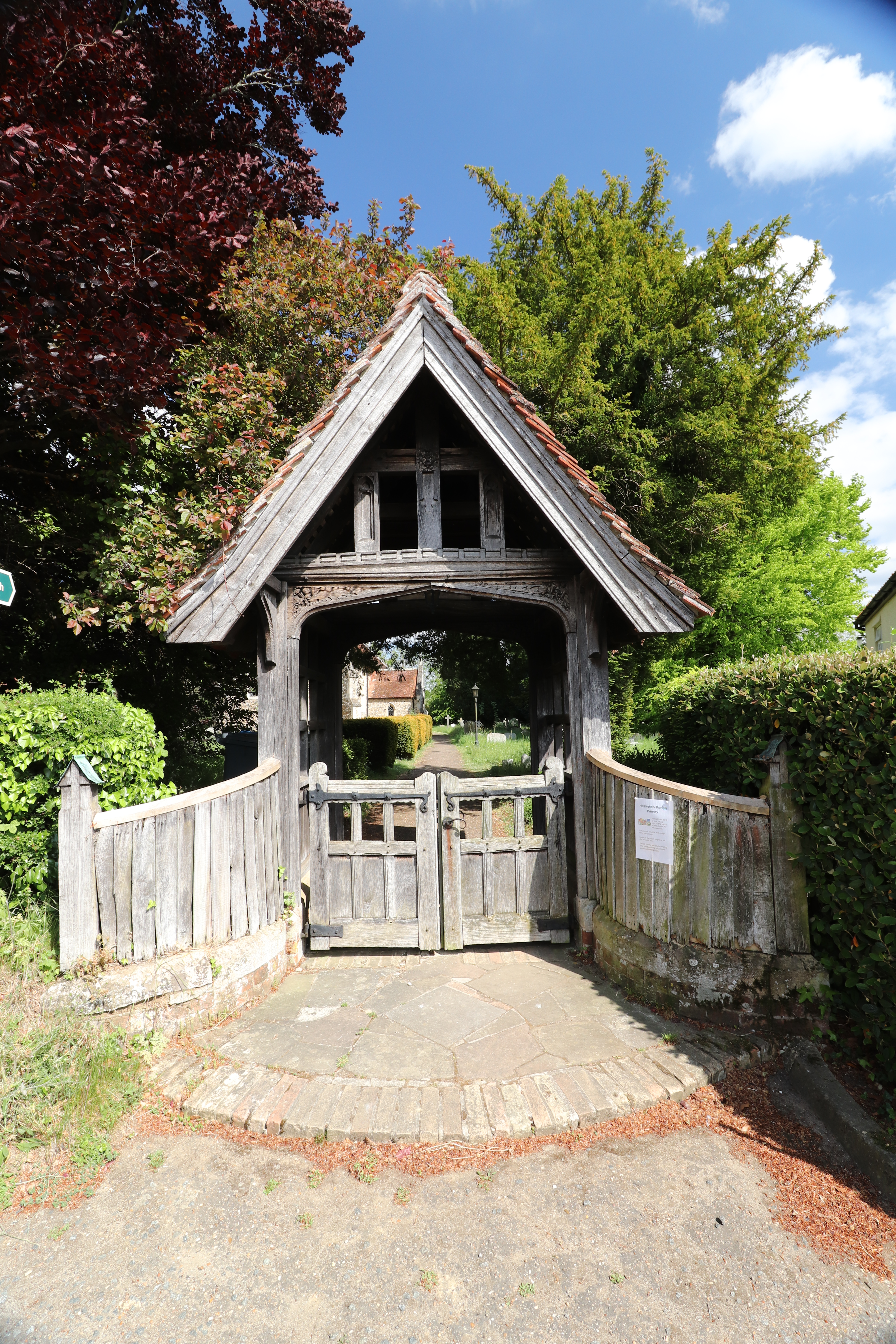
Hasketon is a small village in Suffolk, England. Its church, St. Andrews, is one of 38 existing round-tower churches in Suffolk. St. Andrews stands more or less at the centre of its scattered parish, and is set in a tree-shaded churchyard which, in 1845, had been planted with beech, fir and elm.
Obviously nobody spotted the limes or yews in the churchyard, and of course the elms are long gone, but I don’t mind being ‘scattered’.
In 1870-72, John Marius Wilson’s Imperial Gazetteer of England and Wales described the village as:
HASKETON, a parish in Woodbridge district, Suffolk; 2 miles NW of Woodbridge town and r. station. Post town, Woodbridge. Acres, 1,665. Real property, £3,411. Pop., 483. Houses, 119. The property is much subdivided. The manor belongs to the Rev. Thomas Maude. The living is a rectory in the diocese of Norwich. Value, £290. Patron, the Rev. T. Maude. The church is a brick edifice, with a stone tower, round in the lower part and octagonal in the upper. There is a national school, and charities £61.
OK, also a bit dull, and of course the Rev. Thomas Maude is long gone, but can he really not think of a better word to describe our fine church, with all it’s centuries of history, than ‘edifice’? These days John Marius Wilson is now largely forgotten and, based on this, rightly so.
One of the striking things about all these accounts is they all describe the church in great detail, but rarely mention the pub. Odd, because I can’t believe none of them spent any time there.
I think the nicest write-up is by Arthur Mee in the Kings England, Suffolk, 1941. So nice in fact that I’ve included it all. I’m sure he won’t mind.
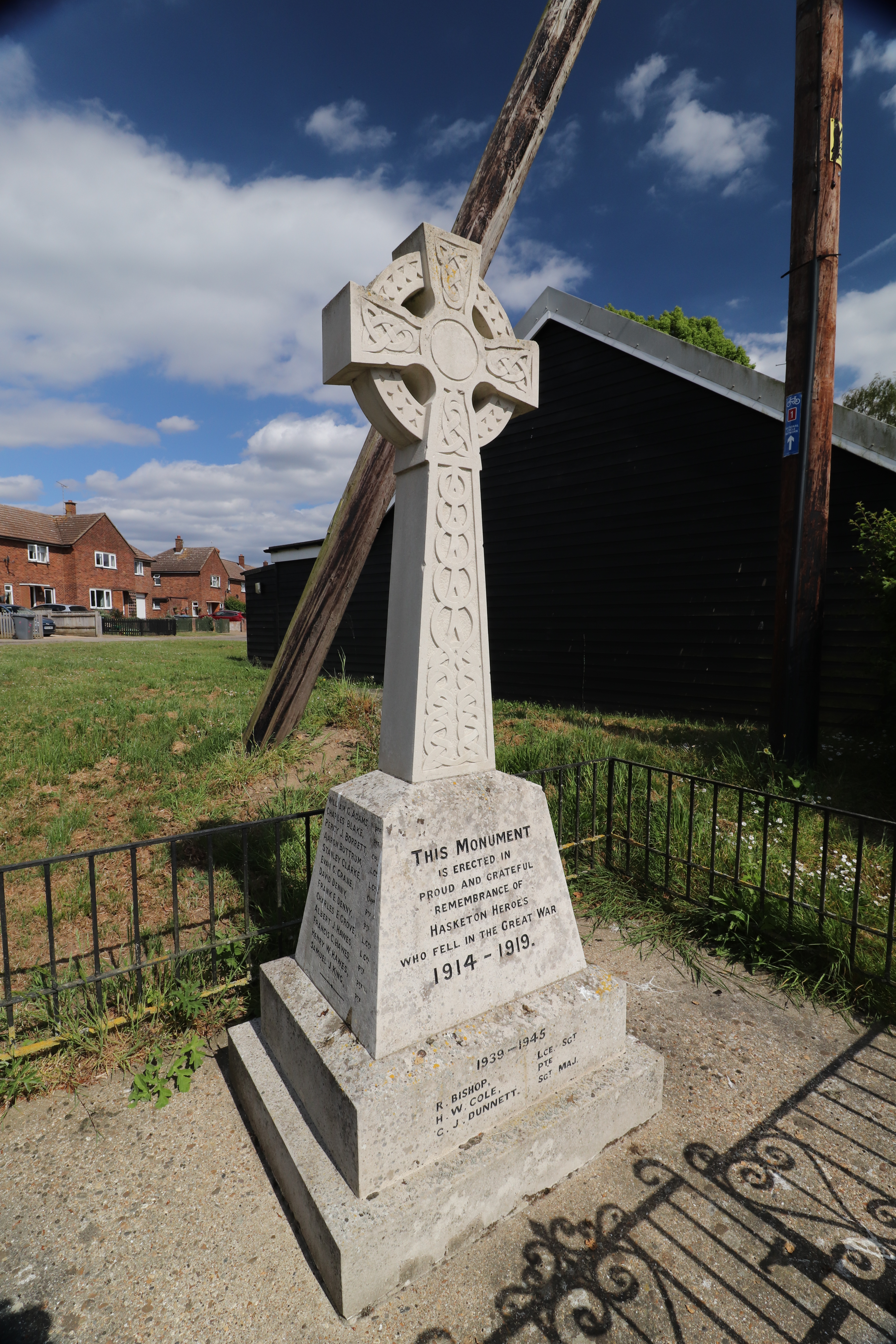
Here at a quiet corner of Hasketon, with the peace memorial cross close by, stands a long medieval church ringed in by fine beeches and limes. Most of it is 14th and 15th century, but not all, for there are some Norman walls, immensely thick, and a fascinating fragment of Saxon workmanship put back by the Normans during their rebuilding. It is a little blocked-up window seen outside the nave, fascinating because at each side are four round holes, and two more holes in the stone at the head of the window. They are about an inch deep, and in them were found pieces of wood and bark. Such holes were sometimes made by the Saxon masons, who placed in them sticks to form the basis of the wattle-and-daub work of the inner splays of their windows – a very primitive application of the principle which leads a modern engineer to reinforce his concrete with steel. There are similar windows at Wansford in Northamptonshire and at Avebury in Wiltshire.
The tower is a round one with an octagonal top, and its deeply splayed windows show the great thickness of the walls. The nave has a panelled roof with three old carved beams, and in the chancel roof are 48 wooden bosses. There are four angels on the choir-stalls, and others with shields on the handsome font, which rests on a panelled shaft. A bishop and a king are carved on the corbels of the vestry doorway.
In the top of the chancel window are fragments of old heraldic glass, perhaps the arms of Sir William Brewse, who restored the church at Hasketon soon after the first Tudor king came to the throne. The east window shows the Crucifixion, the Last Supper, and other Bible scenes. A 17th century stone has richly painted shields in memory of William Goodwyn and his two sons; and a tablet tells of two brothers who gave their lives for England, one on the Somme and one in the Battle of Jutland. The reredos is also in their memory.
Two stones in the Hasketon churchyard are to faithful servants of 40 years, and a third to Susan Harvey, schoolmistress for half a century
What happens in Hasketon?
I suppose the best way to pick up the local vibe is to look at what’s actually going on. Usually the answer in Hasketon is simply, ‘not very much’ – there are only 400 of us after all – but we do have our moments. The village website, and a couple of fairly active facebook pages, Hasketon Happenings and Hasketon Events should provide some idea of current options.
We have the usual Church services on Sunday and other offices at Christmas and Easter. Details of these can be found at the ‘Church Near You‘ website.
We have a Plant and Book Sale in the Spring, usually on the May bank holiday; a Village Fete somtime around late July, and a Charity Sale in late November. There’s Ballroom and Latin dancing classes in the Victory Hall on Wednesday evenings, and the card sharks meet on most Saturday evenings for their whist drive. Once a month there’s a Sunday morning Breakfast Club.
When we first arrived in the village there was a very active mother and toddler group which net once a week in the Victory Hall. Most of those ‘toddlers’ have now just left university and, as I understand it, the group is no longer running due to a lack of replacements. However, the equipment, toys etc still exist, so it’s over to the next generation to restart if appropriate!
The Turk’s Head is open for drinking and food most times you need it.
We are, of course, online. In fact, speeds of about 40Mbits/sec are commonplace, so we’re quite 21st Century. In fact the telecommunications in the village is far better than the drainage system.

is there a mother and baby group at all ?
where is the closest primary school please x
No mother and baby group currently, but there may young families in the village who would be supportive. The PC would also be supportive. See the hasketon Facebook pages for more.
Catchment primary school used to be Woodbridge primary school – the furthest away! Local C of E school is St Mary’s, other choice is Kyson. I think they’re all pretty good.
LikeLike